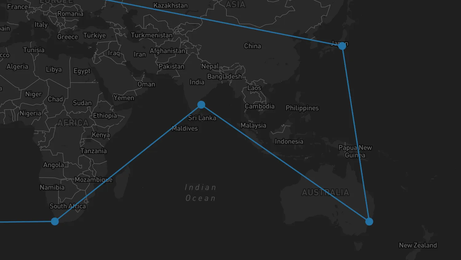
The network layer is used to add graph visualizations to your map. This graph shows cities as fixed nodes with links between them.
NetworkLayerAPI- Network Layer docs
import { MapWeave } from "mapweave/mapbox";
import { NetworkLayer } from "mapweave/layers";
import { networkData } from "./data";

const mapweave = new MapWeave({
  container: "mw",
  options: { accessToken: VITE_MAPBOX_API_KEY },
});
const networkLayer = new NetworkLayer({ data: networkData });
mapweave.addLayer(networkLayer);
mapweave.fitBounds();export const networkData = {
"Buenos Aires": {
type: "node",
color: "#2471a3",
latitude: -34.6,
longitude: -58.38,
},
"Cape Town": {
type: "node",
color: "#2471a3",
latitude: -33.91,
longitude: 18.45,
},
Chennai: {
type: "node",
color: "#2471a3",
latitude: 13.1021,
longitude: 80.2974,
},
Sydney: {
type: "node",
color: "#2471a3",
latitude: -33.9701,
longitude: 151.2185,
},
Tokyo: {
type: "node",
color: "#2471a3",
latitude: 35.5,
longitude: 139.8,
},
Bremerhaven: {
type: "node",
color: "#2471a3",
latitude: 53.5653,
longitude: 8.5442,
},
"Los Angeles": {
type: "node",
color: "#2471a3",
latitude: 33.75,
longitude: -118.19,
},
"Cape Town-Buenos Aires": {
type: "link",
id1: "Cape Town",
id2: "Buenos Aires",
color: "#2471a3",
label: {
text: "No route data",
backgroundColor: "orange",
color: "black",
visible: false,
},
},
"Chennai-Cape Town": {
type: "link",
id1: "Chennai",
id2: "Cape Town",
color: "#2471a3",
route: [
// === CHENNAI HARBOUR DEPARTURE ===
{ latitude: 13.1021, longitude: 80.2974 }, // Chennai Harbour Container Berth
{ latitude: 13.098, longitude: 80.315 }, // Artificial Breakwater Entrance Gates
{ latitude: 13.05, longitude: 80.35 }, // Chennai Outer Anchorage Zone
{ latitude: 11.5, longitude: 81.5 }, // Leaving the Indian East Coast
// === BAY OF BENGAL & EQUATORIAL CROSSING ===
{ latitude: 5.0, longitude: 80.5 }, // South of Sri Lanka (Dondra Head)
{ latitude: 0.0, longitude: 75.0 }, // Crossing the Equator (West of Maldives)
// === INDIAN OCEAN SOUTHWEST TRANSIT (LOW GRANULARITY) ===
{ latitude: -10.0, longitude: 65.0 }, // South Indian Ocean open basin
{ latitude: -20.0, longitude: 55.0 }, // Passing well east of Madagascar
{ latitude: -28.0, longitude: 46.0 }, // Squeezing south of Madagascar's southern shelf
// === APPROAChING SOUTH AFRICA (AGULHAS CURRENT CORRIDOR) ===
{ latitude: -33.5, longitude: 33.0 }, // Approaching the South African coast (off East London)
{ latitude: -34.5, longitude: 26.0 }, // Tracking the Agulhas Bank (off Port Elizabeth)
{ latitude: -35.2, longitude: 20.0 }, // Rounding Cape Agulhas (Southernmost tip of Africa)
{ latitude: -34.4, longitude: 18.4 }, // Rounding the Cape of Good Hope
// === CAPE TOWN HARBOUR ARRIVAL ===
{ latitude: -33.805, longitude: 18.15 }, // Sea Buoy / Entry into Table Bay
{ latitude: -33.821, longitude: 18.332 }, // Clearing Robben Island (West side)
{ latitude: -33.882, longitude: 18.421 }, // Table Bay Navigation Channel
{ latitude: -33.9032, longitude: 18.4355 }, // Harbour Entrance / Breakwater Pier
{ latitude: -33.911, longitude: 18.432 }, // Duncan Dock (Berth / Final Destination)
],
},
"Chennai-Sydney": {
type: "link",
id1: "Sydney",
id2: "Chennai",
color: "#2471a3",
route: [
// === SYDNEY HARBOUR (PORT BOTANY) DEPARTURE ===
{ latitude: -33.9701, longitude: 151.2185 }, // Port Botany Container Terminal Berth
{ latitude: -33.978, longitude: 151.225 }, // Botany Bay Dredged Channel
{ latitude: -33.995, longitude: 151.25 }, // Between Cape Banks and Inscription Point
{ latitude: -34.0, longitude: 151.3 }, // Leaving Botany Bay Approach Lanes
{ latitude: -33.85, longitude: 151.35 }, // Clearing Sydney Heads offshore
// === AUSTRALIAN EAST & NORTH COAST (LOW GRANULARITY) ===
{ latitude: -28.5, longitude: 154.0 }, // Offshore Cape Byron
{ latitude: -23.0, longitude: 154.5 }, // Coral Sea Corridor (Bypassing Great Barrier Reef)
{ latitude: -11.0, longitude: 144.0 }, // Torres Strait Entrance (Great North East Channel)
{ latitude: -10.5, longitude: 142.2 }, // Prince of Wales Channel (Torres Strait Chokepoint)
// === ARAFURA & TIMOR SEAS ===
{ latitude: -10.0, longitude: 137.0 }, // Arafura Sea Central
{ latitude: -9.0, longitude: 130.0 }, // Timor Sea (North of Darwin)
{ latitude: -8.5, longitude: 120.0 }, // Savu Sea Transit
// === INDONESIAN ARCHIPELAGO GATEWAY (LOMBOK STRAIT) ===
{ latitude: -8.75, longitude: 115.75 }, // Southern Entrance to Lombok Strait
{ latitude: -8.4, longitude: 115.7 }, // Mid-Strait Passage (Between Bali and Lombok)
{ latitude: -7.9, longitude: 115.65 }, // Java Sea Exit Corridor
// === INDIAN OCEAN NORTH-WEST TRANSIT ===
{ latitude: -5.0, longitude: 105.0 }, // South of Sunda Strait / West of Java
{ latitude: 0.0, longitude: 95.0 }, // Crossing the Equator (West of Sumatra)
{ latitude: 6.0, longitude: 88.0 }, // Entering the Bay of Bengal
// === CHENNAI HARBOUR APPROACH ===
{ latitude: 11.5, longitude: 81.5 }, // Approaching the Indian East Coast
{ latitude: 13.05, longitude: 80.35 }, // Chennai Outer Anchorage Zone
{ latitude: 13.098, longitude: 80.315 }, // Artificial Breakwater Entrance Gates
{ latitude: 13.1021, longitude: 80.2974 }, // Chennai Harbour Container Berth
],
},
"Sydney-Tokyo": {
type: "link",
id1: "Tokyo",
id2: "Sydney",
color: "#2471a3",
route: [
// === TOKYO BAY DEPARTURE ===
{ latitude: 35.618, longitude: 139.776 }, // Tokyo Port (Oi Container Wharves)
{ latitude: 35.6, longitude: 139.78 }, // Tokyo Oi Container Terminal Outer Basin
{ latitude: 35.35, longitude: 139.8 }, // Central Tokyo Bay Shipping Lane
{ latitude: 35.15, longitude: 139.75 }, // Uraga Channel (Narrow entry corridor)
{ latitude: 34.6, longitude: 139.8 }, // Nojima Saki (Leaving Tokyo Bay Traffic Scheme)
// === WESTERN PACIFIC SOUTHBOUND TRANSIT (LOW GRANULARITY) ===
{ latitude: 28.0, longitude: 141.0 }, // Passing east of the Ogasawara Islands
{ latitude: 15.0, longitude: 144.5 }, // West of Saipan / Mariana Islands
{ latitude: 5.0, longitude: 147.0 }, // Open Pacific (North of Papua New Guinea)
// === MELANESIA ISLAND PASSAGE (LAND AVOIDANCE GAPS) ===
{ latitude: -3.5, longitude: 152.5 }, // St. George's Channel (Between New Ireland & New Britain)
{ latitude: -6.0, longitude: 154.5 }, // Solomon Sea (West of Bougainville Island)
{ latitude: -11.0, longitude: 156.5 }, // Jomard Entrance / Louisiade Archipelago Gap
// === CORAL SEA & AUSTRALIAN EAST COAST TRANSIT ===
{ latitude: -16.0, longitude: 155.0 }, // Central Coral Sea (Avoiding Great Barrier Reef)
{ latitude: -23.0, longitude: 154.5 }, // Offshore Gladstone / Fraser Island, Australia
{ latitude: -28.5, longitude: 154.0 }, // Offshore Cape Byron (Australia's easternmost point)
{ latitude: -32.5, longitude: 152.5 }, // Offshore Newcastle / Port Stephens
// === SYDNEY HARBOUR (PORT BOTANY) ARRIVAL ===
{ latitude: -33.85, longitude: 151.35 }, // Approaching Sydney Heads offshore
{ latitude: -34.0, longitude: 151.3 }, // Entering Botany Bay Approach Lanes
{ latitude: -33.995, longitude: 151.25 }, // Between Cape Banks and Inscription Point
{ latitude: -33.978, longitude: 151.225 }, // Botany Bay Dredged Channel Entrance
{ latitude: -33.9701, longitude: 151.2185 }, // Port Botany Container Terminal Berth
],
},
"Bremerhaven-Tokyo": {
type: "link",
id1: "Bremerhaven",
id2: "Tokyo",
color: "#2471a3",
route: [
// === BREMERHAVEN HARBOUR DEPARTURE ===
{ latitude: 53.5653, longitude: 8.5442 }, // Container-Terminal Bremerhaven Berth
{ latitude: 53.585, longitude: 8.537 }, // Turning Basin / Northern Lock Gates Area
{ latitude: 53.64, longitude: 8.51 }, // Weser River Channel
{ latitude: 53.75, longitude: 8.42 }, // Weser River Estuary Entrance Channel
{ latitude: 54.0, longitude: 7.8 }, // Außenweser Approach (German Bight)
// === NORTH SEA & ENGLISH CHANNEL PASSAGE ===
{ latitude: 53.0, longitude: 4.3 }, // North Sea Traffic Lanes (Off Dutch Coast)
{ latitude: 51.1, longitude: 1.5 }, // Strait of Dover (Narrowest point)
{ latitude: 50.4, longitude: -0.5 }, // Mid-Channel Traffic Separation Scheme
{ latitude: 49.95, longitude: -5.0 }, // Channel Exit (Off Lizard Point)
// === BAY OF BISCAY & PORTUGUESE COAST ===
{ latitude: 45.0, longitude: -8.0 }, // Crossing the Bay of Biscay
{ latitude: 42.5, longitude: -9.5 }, // Clearing Cape Finisterre (Spain)
{ latitude: 38.8, longitude: -9.6 }, // Offshore Lisbon (Portugal)
{ latitude: 36.9, longitude: -9.2 }, // Rounding Cape St. Vincent (Portugal)
{ latitude: 36.1, longitude: -7.5 }, // Gulf of Cádiz Approach
// === STRAIT OF GIBRALTAR GAPS ===
{ latitude: 35.95, longitude: -5.8 }, // Western Entrance to Gibraltar Strait
{ latitude: 35.95, longitude: -5.4 }, // Mid-Strait Traffic Separation Scheme
{ latitude: 36.05, longitude: -5.0 }, // Alboran Sea Entry (Clearing Gibraltar Rock)
// === MEDITERRANEAN SEA OPEN WATERS (LAND AVOIDANCE CORRIDORS) ===
{ latitude: 36.5, longitude: -2.0 }, // Clearing Almería (Spain) to the north
{ latitude: 36.8, longitude: 1.0 }, // South of Balearic Islands / North of Algeria
{ latitude: 37.4, longitude: 5.0 }, // Open Western Mediterranean
{ latitude: 37.9, longitude: 8.0 }, // Passing North of Tunisia / South of Sardinia
// === STRAIT OF SICILY CHANNELS ===
{ latitude: 37.3, longitude: 11.2 }, // Heading into the Strait of Sicily
{ latitude: 36.5, longitude: 12.5 }, // Deep water corridor between Tunisia and Sicily
{ latitude: 35.8, longitude: 14.8 }, // Passing South of Malta
{ latitude: 34.5, longitude: 19.0 }, // Open Ionian/Libyan Sea Corridor
{ latitude: 33.0, longitude: 25.0 }, // South of Crete (Greece)
{ latitude: 31.8, longitude: 30.0 }, // Levantine Basin (Approaching Egypt)
// === SUEZ CANAL TRANSIT ===
{ latitude: 31.26, longitude: 32.32 }, // Port Said (Mediterranean Entrance)
{ latitude: 30.58, longitude: 32.27 }, // Ismailia (Lake Timsah)
{ latitude: 30.29, longitude: 32.51 }, // Great Bitter Lake
{ latitude: 29.93, longitude: 32.57 }, // Port of Suez (Red Sea Exit)
// === RED SEA & INDIAN OCEAN TRANSIT ===
{ latitude: 24.0, longitude: 37.5 }, // Mid-Red Sea
{ latitude: 12.6, longitude: 43.4 }, // Bab-el-Mandeb Strait
{ latitude: 12.0, longitude: 51.0 }, // Guardafui Channel (Off Horn of Africa)
{ latitude: 6.0, longitude: 79.5 }, // South of Dondra Head, Sri Lanka
// === STRAIT OF MALACCA TRANSIT ===
{ latitude: 5.5, longitude: 95.0 }, // Entrance to Malacca Strait (Off Banda Aceh)
{ latitude: 4.0, longitude: 99.0 }, // One Fathom Bank Traffic Separation Scheme
{ latitude: 1.25, longitude: 103.6 }, // Singapore Strait (Western Entrance)
{ latitude: 1.3, longitude: 104.3 }, // Horsburgh Lighthouse (Leaving Singapore Strait)
// === SOUTH CHINA SEA & PACIFIC OCEAN ===
{ latitude: 10.0, longitude: 110.0 }, // South China Sea Central
{ latitude: 22.0, longitude: 120.5 }, // Luzon Strait (South of Taiwan)
{ latitude: 28.0, longitude: 130.0 }, // East of Ryukyu Islands
{ latitude: 33.5, longitude: 136.0 }, // Approaching the Kii Peninsula, Japan
// === TOKYO BAY APPROACH & HARBOUR ARRIVAL ===
{ latitude: 34.6, longitude: 139.8 }, // Nojima Saki (Entrance to Tokyo Bay Traffic Scheme)
{ latitude: 35.15, longitude: 139.75 }, // Uraga Channel (Narrow entry corridor)
{ latitude: 35.35, longitude: 139.8 }, // Central Tokyo Bay Shipping Lane
{ latitude: 35.6, longitude: 139.78 }, // Tokyo Oi Container Terminal Outer Basin
{ latitude: 35.618, longitude: 139.776 }, // Tokyo Port (Oi Container Wharves)
],
},
"Bremerhaven-Los Angeles": {
type: "link",
id1: "Los Angeles",
id2: "Bremerhaven",
color: "#2471a3",
route: [
// === LONG BEACH HARBOUR DEPARTURE ===
{ latitude: 33.7553, longitude: -118.213 }, // Port of Long Beach Terminal
{ latitude: 33.74, longitude: -118.215 }, // Middle Harbor Channel
{ latitude: 33.705, longitude: -118.21 }, // Queen's Gate Breakwater Exit
{ latitude: 33.5, longitude: -118.25 }, // Leaving San Pedro Bay Traffic Lanes
{ latitude: 32.5, longitude: -118.0 }, // Clearing Southern California Bight
// === PACIFIC OCEAN SOUTHBOUND TRANSIT (LOW GRANULARITY) ===
{ latitude: 23.0, longitude: -110.5 }, // Offshore Baja California (Cabo San Lucas)
{ latitude: 16.0, longitude: -101.0 }, // Offshore Southern Mexico
{ latitude: 9.5, longitude: -86.0 }, // Approaching Costa Rica
// === PANAMA CANAL TRANSIT (HIGH GRANULARITY) ===
{ latitude: 8.889, longitude: -79.529 }, // Pacific Entrance / Balboa Anchorage
{ latitude: 8.995, longitude: -79.591 }, // Miraflores & Pedro Miguel Locks
{ latitude: 9.163, longitude: -79.827 }, // Gatun Lake Navigation Channel
{ latitude: 9.271, longitude: -79.923 }, // Gatun Locks / Agua Clara Locks
{ latitude: 9.38, longitude: -79.94 }, // Caribbean Entrance / Cristóbal Sea Buoy
// === CARIBBEAN & NORTH ATLANTIC TRANSIT (LOW GRANULARITY) ===
{ latitude: 14.0, longitude: -75.0 }, // Central Caribbean Sea
{ latitude: 20.0, longitude: -73.8 }, // Windward Passage (Between Cuba & Haiti)
{ latitude: 24.0, longitude: -73.0 }, // Entering open North Atlantic (East of Bahamas)
{ latitude: 35.0, longitude: -55.0 }, // Mid-Atlantic West
{ latitude: 45.0, longitude: -30.0 }, // Mid-Atlantic East
{ latitude: 49.5, longitude: -7.0 }, // Approaching the Southwest Approaches / Celtic Sea
// === ENGLISH CHANNEL & NORTH SEA PASSAGE ===
{ latitude: 49.95, longitude: -5.0 }, // Channel Entrance (Off Lizard Point)
{ latitude: 50.4, longitude: -0.5 }, // Mid-Channel Traffic Separation Scheme
{ latitude: 51.1, longitude: 1.5 }, // Strait of Dover (Narrowest point)
{ latitude: 53.0, longitude: 4.3 }, // North Sea Traffic Lanes (Off Dutch Coast)
{ latitude: 54.0, longitude: 7.8 }, // Außenweser Approach (German Bight)
// === BREMERHAVEN HARBOUR ARRIVAL ===
{ latitude: 53.75, longitude: 8.42 }, // Weser River Estuary Entrance Channel
{ latitude: 53.64, longitude: 8.51 }, // Passing Fedderwardersiel
{ latitude: 53.585, longitude: 8.537 }, // Turning Basin / Northern Lock Gates Area
{ latitude: 53.5653, longitude: 8.5442 }, // Container-Terminal Bremerhaven Berth
],
},
"Los Angeles-Buenos Aires": {
type: "link",
id1: "Buenos Aires",
id2: "Los Angeles",
color: "#2471a3",
route: [
// === BUENOS AIRES HARBOUR DEPARTURE ===
{ latitude: -34.592, longitude: -58.358 }, // Puerto de Buenos Aires (Departure)
{ latitude: -34.604, longitude: -58.331 }, // Canal de Acceso (Inner)
{ latitude: -34.622, longitude: -58.21 }, // Canal de Acceso (Outer)
{ latitude: -34.698, longitude: -57.92 }, // Canal Paso Banco Chico
{ latitude: -34.912, longitude: -57.42 }, // Canal Intermedio
{ latitude: -35.031, longitude: -56.88 }, // Canal Punta Indio
{ latitude: -35.15, longitude: -55.5 }, // Estuary Exit (Recalada Pilot Station)
// === SOUTH ATLANTIC COASTAL COUPLING (LOW GRANULARITY) ===
{ latitude: -38.5, longitude: -56.5 }, // Clearing Mar del Plata, Argentina
{ latitude: -44.0, longitude: -62.0 }, // Crossing the Golfo San Jorge open waters
{ latitude: -51.0, longitude: -66.5 }, // Approaching the southern tip of Argentina
// === STRAIT OF MAGELLAN PASSAGE ===
{ latitude: -52.4, longitude: -68.4 }, // Eastern Entrance (Punta Dungeness)
{ latitude: -52.25, longitude: -69.45 }, // First Narrows (Primera Angostura)
{ latitude: -52.95, longitude: -70.4 }, // Second Narrows (Segunda Angostura)
{ latitude: -53.65, longitude: -70.95 }, // Paso Froward (Southernmost point of the continent)
{ latitude: -53.15, longitude: -73.0 }, // Paso Largo
{ latitude: -52.65, longitude: -74.5 }, // Canal Smyth Junction
{ latitude: -52.6, longitude: -75.2 }, // Western Entrance (Cabo Pilar into the Pacific)
// === PACIFIC OCEAN NORTHBOUND TRANSIT (LOW GRANULARITY) ===
{ latitude: -45.0, longitude: -76.5 }, // Chilean Coast offshore
{ latitude: -33.0, longitude: -74.0 }, // Level with Valparaíso
{ latitude: -20.0, longitude: -73.0 }, // Level with Iquique
{ latitude: -5.0, longitude: -82.0 }, // Clearing the western bulge of Peru (Paita)
{ latitude: 5.0, longitude: -85.0 }, // Crossing the Equator / West of Cocos Island
{ latitude: 15.0, longitude: -98.0 }, // West of Central America
{ latitude: 23.0, longitude: -112.0 }, // Level with Cabo San Lucas (Baja California)
{ latitude: 30.0, longitude: -116.5 }, // Northbound along Baja Peninsula
// === LONG BEACH HARBOUR APPROACH ===
{ latitude: 32.5, longitude: -118.0 }, // Heading into the Southern California Bight
{ latitude: 33.5, longitude: -118.25 }, // Entering San Pedro Bay Traffic Separation Zone
{ latitude: 33.705, longitude: -118.21 }, // San Pedro Breakwater Entrance (Queen's Gate)
{ latitude: 33.74, longitude: -118.215 }, // Long Beach Middle Harbor Navigation Channel
{ latitude: 33.755, longitude: -118.213 }, // Port of Long Beach (Container Terminal Basin)
],
},
};<!doctype html>
<html>
<head>
<link rel="stylesheet" href="@ci/theme/mw/css/examples.css" />
</head>
<body>
<div id="mw"></div>
<script type="module" src="./code.js"></script>
</body>
</html>import React from "react";
import { createRoot } from "react-dom/client";
import { MapWeave } from "mapweave/react/mapbox";
import { NetworkLayer } from "mapweave/react/layers";
import { networkData } from "./data";
const mapWeaveOptions = { accessToken: VITE_MAPBOX_API_KEY };
function Demo() {
return (
<MapWeave options={mapWeaveOptions}>
<NetworkLayer data={networkData} />
</MapWeave>
);
}
const root = createRoot(document.getElementById("mw"));
root.render(<Demo />);export const networkData = {
"Buenos Aires": {
type: "node",
color: "#2471a3",
latitude: -34.6,
longitude: -58.38,
},
"Cape Town": {
type: "node",
color: "#2471a3",
latitude: -33.91,
longitude: 18.45,
},
Chennai: {
type: "node",
color: "#2471a3",
latitude: 13.1021,
longitude: 80.2974,
},
Sydney: {
type: "node",
color: "#2471a3",
latitude: -33.9701,
longitude: 151.2185,
},
Tokyo: {
type: "node",
color: "#2471a3",
latitude: 35.5,
longitude: 139.8,
},
Bremerhaven: {
type: "node",
color: "#2471a3",
latitude: 53.5653,
longitude: 8.5442,
},
"Los Angeles": {
type: "node",
color: "#2471a3",
latitude: 33.75,
longitude: -118.19,
},
"Cape Town-Buenos Aires": {
type: "link",
id1: "Cape Town",
id2: "Buenos Aires",
color: "#2471a3",
label: {
text: "No route data",
backgroundColor: "orange",
color: "black",
visible: false,
},
},
"Chennai-Cape Town": {
type: "link",
id1: "Chennai",
id2: "Cape Town",
color: "#2471a3",
route: [
// === CHENNAI HARBOUR DEPARTURE ===
{ latitude: 13.1021, longitude: 80.2974 }, // Chennai Harbour Container Berth
{ latitude: 13.098, longitude: 80.315 }, // Artificial Breakwater Entrance Gates
{ latitude: 13.05, longitude: 80.35 }, // Chennai Outer Anchorage Zone
{ latitude: 11.5, longitude: 81.5 }, // Leaving the Indian East Coast
// === BAY OF BENGAL & EQUATORIAL CROSSING ===
{ latitude: 5.0, longitude: 80.5 }, // South of Sri Lanka (Dondra Head)
{ latitude: 0.0, longitude: 75.0 }, // Crossing the Equator (West of Maldives)
// === INDIAN OCEAN SOUTHWEST TRANSIT (LOW GRANULARITY) ===
{ latitude: -10.0, longitude: 65.0 }, // South Indian Ocean open basin
{ latitude: -20.0, longitude: 55.0 }, // Passing well east of Madagascar
{ latitude: -28.0, longitude: 46.0 }, // Squeezing south of Madagascar's southern shelf
// === APPROAChING SOUTH AFRICA (AGULHAS CURRENT CORRIDOR) ===
{ latitude: -33.5, longitude: 33.0 }, // Approaching the South African coast (off East London)
{ latitude: -34.5, longitude: 26.0 }, // Tracking the Agulhas Bank (off Port Elizabeth)
{ latitude: -35.2, longitude: 20.0 }, // Rounding Cape Agulhas (Southernmost tip of Africa)
{ latitude: -34.4, longitude: 18.4 }, // Rounding the Cape of Good Hope
// === CAPE TOWN HARBOUR ARRIVAL ===
{ latitude: -33.805, longitude: 18.15 }, // Sea Buoy / Entry into Table Bay
{ latitude: -33.821, longitude: 18.332 }, // Clearing Robben Island (West side)
{ latitude: -33.882, longitude: 18.421 }, // Table Bay Navigation Channel
{ latitude: -33.9032, longitude: 18.4355 }, // Harbour Entrance / Breakwater Pier
{ latitude: -33.911, longitude: 18.432 }, // Duncan Dock (Berth / Final Destination)
],
},
"Chennai-Sydney": {
type: "link",
id1: "Sydney",
id2: "Chennai",
color: "#2471a3",
route: [
// === SYDNEY HARBOUR (PORT BOTANY) DEPARTURE ===
{ latitude: -33.9701, longitude: 151.2185 }, // Port Botany Container Terminal Berth
{ latitude: -33.978, longitude: 151.225 }, // Botany Bay Dredged Channel
{ latitude: -33.995, longitude: 151.25 }, // Between Cape Banks and Inscription Point
{ latitude: -34.0, longitude: 151.3 }, // Leaving Botany Bay Approach Lanes
{ latitude: -33.85, longitude: 151.35 }, // Clearing Sydney Heads offshore
// === AUSTRALIAN EAST & NORTH COAST (LOW GRANULARITY) ===
{ latitude: -28.5, longitude: 154.0 }, // Offshore Cape Byron
{ latitude: -23.0, longitude: 154.5 }, // Coral Sea Corridor (Bypassing Great Barrier Reef)
{ latitude: -11.0, longitude: 144.0 }, // Torres Strait Entrance (Great North East Channel)
{ latitude: -10.5, longitude: 142.2 }, // Prince of Wales Channel (Torres Strait Chokepoint)
// === ARAFURA & TIMOR SEAS ===
{ latitude: -10.0, longitude: 137.0 }, // Arafura Sea Central
{ latitude: -9.0, longitude: 130.0 }, // Timor Sea (North of Darwin)
{ latitude: -8.5, longitude: 120.0 }, // Savu Sea Transit
// === INDONESIAN ARCHIPELAGO GATEWAY (LOMBOK STRAIT) ===
{ latitude: -8.75, longitude: 115.75 }, // Southern Entrance to Lombok Strait
{ latitude: -8.4, longitude: 115.7 }, // Mid-Strait Passage (Between Bali and Lombok)
{ latitude: -7.9, longitude: 115.65 }, // Java Sea Exit Corridor
// === INDIAN OCEAN NORTH-WEST TRANSIT ===
{ latitude: -5.0, longitude: 105.0 }, // South of Sunda Strait / West of Java
{ latitude: 0.0, longitude: 95.0 }, // Crossing the Equator (West of Sumatra)
{ latitude: 6.0, longitude: 88.0 }, // Entering the Bay of Bengal
// === CHENNAI HARBOUR APPROACH ===
{ latitude: 11.5, longitude: 81.5 }, // Approaching the Indian East Coast
{ latitude: 13.05, longitude: 80.35 }, // Chennai Outer Anchorage Zone
{ latitude: 13.098, longitude: 80.315 }, // Artificial Breakwater Entrance Gates
{ latitude: 13.1021, longitude: 80.2974 }, // Chennai Harbour Container Berth
],
},
"Sydney-Tokyo": {
type: "link",
id1: "Tokyo",
id2: "Sydney",
color: "#2471a3",
route: [
// === TOKYO BAY DEPARTURE ===
{ latitude: 35.618, longitude: 139.776 }, // Tokyo Port (Oi Container Wharves)
{ latitude: 35.6, longitude: 139.78 }, // Tokyo Oi Container Terminal Outer Basin
{ latitude: 35.35, longitude: 139.8 }, // Central Tokyo Bay Shipping Lane
{ latitude: 35.15, longitude: 139.75 }, // Uraga Channel (Narrow entry corridor)
{ latitude: 34.6, longitude: 139.8 }, // Nojima Saki (Leaving Tokyo Bay Traffic Scheme)
// === WESTERN PACIFIC SOUTHBOUND TRANSIT (LOW GRANULARITY) ===
{ latitude: 28.0, longitude: 141.0 }, // Passing east of the Ogasawara Islands
{ latitude: 15.0, longitude: 144.5 }, // West of Saipan / Mariana Islands
{ latitude: 5.0, longitude: 147.0 }, // Open Pacific (North of Papua New Guinea)
// === MELANESIA ISLAND PASSAGE (LAND AVOIDANCE GAPS) ===
{ latitude: -3.5, longitude: 152.5 }, // St. George's Channel (Between New Ireland & New Britain)
{ latitude: -6.0, longitude: 154.5 }, // Solomon Sea (West of Bougainville Island)
{ latitude: -11.0, longitude: 156.5 }, // Jomard Entrance / Louisiade Archipelago Gap
// === CORAL SEA & AUSTRALIAN EAST COAST TRANSIT ===
{ latitude: -16.0, longitude: 155.0 }, // Central Coral Sea (Avoiding Great Barrier Reef)
{ latitude: -23.0, longitude: 154.5 }, // Offshore Gladstone / Fraser Island, Australia
{ latitude: -28.5, longitude: 154.0 }, // Offshore Cape Byron (Australia's easternmost point)
{ latitude: -32.5, longitude: 152.5 }, // Offshore Newcastle / Port Stephens
// === SYDNEY HARBOUR (PORT BOTANY) ARRIVAL ===
{ latitude: -33.85, longitude: 151.35 }, // Approaching Sydney Heads offshore
{ latitude: -34.0, longitude: 151.3 }, // Entering Botany Bay Approach Lanes
{ latitude: -33.995, longitude: 151.25 }, // Between Cape Banks and Inscription Point
{ latitude: -33.978, longitude: 151.225 }, // Botany Bay Dredged Channel Entrance
{ latitude: -33.9701, longitude: 151.2185 }, // Port Botany Container Terminal Berth
],
},
"Bremerhaven-Tokyo": {
type: "link",
id1: "Bremerhaven",
id2: "Tokyo",
color: "#2471a3",
route: [
// === BREMERHAVEN HARBOUR DEPARTURE ===
{ latitude: 53.5653, longitude: 8.5442 }, // Container-Terminal Bremerhaven Berth
{ latitude: 53.585, longitude: 8.537 }, // Turning Basin / Northern Lock Gates Area
{ latitude: 53.64, longitude: 8.51 }, // Weser River Channel
{ latitude: 53.75, longitude: 8.42 }, // Weser River Estuary Entrance Channel
{ latitude: 54.0, longitude: 7.8 }, // Außenweser Approach (German Bight)
// === NORTH SEA & ENGLISH CHANNEL PASSAGE ===
{ latitude: 53.0, longitude: 4.3 }, // North Sea Traffic Lanes (Off Dutch Coast)
{ latitude: 51.1, longitude: 1.5 }, // Strait of Dover (Narrowest point)
{ latitude: 50.4, longitude: -0.5 }, // Mid-Channel Traffic Separation Scheme
{ latitude: 49.95, longitude: -5.0 }, // Channel Exit (Off Lizard Point)
// === BAY OF BISCAY & PORTUGUESE COAST ===
{ latitude: 45.0, longitude: -8.0 }, // Crossing the Bay of Biscay
{ latitude: 42.5, longitude: -9.5 }, // Clearing Cape Finisterre (Spain)
{ latitude: 38.8, longitude: -9.6 }, // Offshore Lisbon (Portugal)
{ latitude: 36.9, longitude: -9.2 }, // Rounding Cape St. Vincent (Portugal)
{ latitude: 36.1, longitude: -7.5 }, // Gulf of Cádiz Approach
// === STRAIT OF GIBRALTAR GAPS ===
{ latitude: 35.95, longitude: -5.8 }, // Western Entrance to Gibraltar Strait
{ latitude: 35.95, longitude: -5.4 }, // Mid-Strait Traffic Separation Scheme
{ latitude: 36.05, longitude: -5.0 }, // Alboran Sea Entry (Clearing Gibraltar Rock)
// === MEDITERRANEAN SEA OPEN WATERS (LAND AVOIDANCE CORRIDORS) ===
{ latitude: 36.5, longitude: -2.0 }, // Clearing Almería (Spain) to the north
{ latitude: 36.8, longitude: 1.0 }, // South of Balearic Islands / North of Algeria
{ latitude: 37.4, longitude: 5.0 }, // Open Western Mediterranean
{ latitude: 37.9, longitude: 8.0 }, // Passing North of Tunisia / South of Sardinia
// === STRAIT OF SICILY CHANNELS ===
{ latitude: 37.3, longitude: 11.2 }, // Heading into the Strait of Sicily
{ latitude: 36.5, longitude: 12.5 }, // Deep water corridor between Tunisia and Sicily
{ latitude: 35.8, longitude: 14.8 }, // Passing South of Malta
{ latitude: 34.5, longitude: 19.0 }, // Open Ionian/Libyan Sea Corridor
{ latitude: 33.0, longitude: 25.0 }, // South of Crete (Greece)
{ latitude: 31.8, longitude: 30.0 }, // Levantine Basin (Approaching Egypt)
// === SUEZ CANAL TRANSIT ===
{ latitude: 31.26, longitude: 32.32 }, // Port Said (Mediterranean Entrance)
{ latitude: 30.58, longitude: 32.27 }, // Ismailia (Lake Timsah)
{ latitude: 30.29, longitude: 32.51 }, // Great Bitter Lake
{ latitude: 29.93, longitude: 32.57 }, // Port of Suez (Red Sea Exit)
// === RED SEA & INDIAN OCEAN TRANSIT ===
{ latitude: 24.0, longitude: 37.5 }, // Mid-Red Sea
{ latitude: 12.6, longitude: 43.4 }, // Bab-el-Mandeb Strait
{ latitude: 12.0, longitude: 51.0 }, // Guardafui Channel (Off Horn of Africa)
{ latitude: 6.0, longitude: 79.5 }, // South of Dondra Head, Sri Lanka
// === STRAIT OF MALACCA TRANSIT ===
{ latitude: 5.5, longitude: 95.0 }, // Entrance to Malacca Strait (Off Banda Aceh)
{ latitude: 4.0, longitude: 99.0 }, // One Fathom Bank Traffic Separation Scheme
{ latitude: 1.25, longitude: 103.6 }, // Singapore Strait (Western Entrance)
{ latitude: 1.3, longitude: 104.3 }, // Horsburgh Lighthouse (Leaving Singapore Strait)
// === SOUTH CHINA SEA & PACIFIC OCEAN ===
{ latitude: 10.0, longitude: 110.0 }, // South China Sea Central
{ latitude: 22.0, longitude: 120.5 }, // Luzon Strait (South of Taiwan)
{ latitude: 28.0, longitude: 130.0 }, // East of Ryukyu Islands
{ latitude: 33.5, longitude: 136.0 }, // Approaching the Kii Peninsula, Japan
// === TOKYO BAY APPROACH & HARBOUR ARRIVAL ===
{ latitude: 34.6, longitude: 139.8 }, // Nojima Saki (Entrance to Tokyo Bay Traffic Scheme)
{ latitude: 35.15, longitude: 139.75 }, // Uraga Channel (Narrow entry corridor)
{ latitude: 35.35, longitude: 139.8 }, // Central Tokyo Bay Shipping Lane
{ latitude: 35.6, longitude: 139.78 }, // Tokyo Oi Container Terminal Outer Basin
{ latitude: 35.618, longitude: 139.776 }, // Tokyo Port (Oi Container Wharves)
],
},
"Bremerhaven-Los Angeles": {
type: "link",
id1: "Los Angeles",
id2: "Bremerhaven",
color: "#2471a3",
route: [
// === LONG BEACH HARBOUR DEPARTURE ===
{ latitude: 33.7553, longitude: -118.213 }, // Port of Long Beach Terminal
{ latitude: 33.74, longitude: -118.215 }, // Middle Harbor Channel
{ latitude: 33.705, longitude: -118.21 }, // Queen's Gate Breakwater Exit
{ latitude: 33.5, longitude: -118.25 }, // Leaving San Pedro Bay Traffic Lanes
{ latitude: 32.5, longitude: -118.0 }, // Clearing Southern California Bight
// === PACIFIC OCEAN SOUTHBOUND TRANSIT (LOW GRANULARITY) ===
{ latitude: 23.0, longitude: -110.5 }, // Offshore Baja California (Cabo San Lucas)
{ latitude: 16.0, longitude: -101.0 }, // Offshore Southern Mexico
{ latitude: 9.5, longitude: -86.0 }, // Approaching Costa Rica
// === PANAMA CANAL TRANSIT (HIGH GRANULARITY) ===
{ latitude: 8.889, longitude: -79.529 }, // Pacific Entrance / Balboa Anchorage
{ latitude: 8.995, longitude: -79.591 }, // Miraflores & Pedro Miguel Locks
{ latitude: 9.163, longitude: -79.827 }, // Gatun Lake Navigation Channel
{ latitude: 9.271, longitude: -79.923 }, // Gatun Locks / Agua Clara Locks
{ latitude: 9.38, longitude: -79.94 }, // Caribbean Entrance / Cristóbal Sea Buoy
// === CARIBBEAN & NORTH ATLANTIC TRANSIT (LOW GRANULARITY) ===
{ latitude: 14.0, longitude: -75.0 }, // Central Caribbean Sea
{ latitude: 20.0, longitude: -73.8 }, // Windward Passage (Between Cuba & Haiti)
{ latitude: 24.0, longitude: -73.0 }, // Entering open North Atlantic (East of Bahamas)
{ latitude: 35.0, longitude: -55.0 }, // Mid-Atlantic West
{ latitude: 45.0, longitude: -30.0 }, // Mid-Atlantic East
{ latitude: 49.5, longitude: -7.0 }, // Approaching the Southwest Approaches / Celtic Sea
// === ENGLISH CHANNEL & NORTH SEA PASSAGE ===
{ latitude: 49.95, longitude: -5.0 }, // Channel Entrance (Off Lizard Point)
{ latitude: 50.4, longitude: -0.5 }, // Mid-Channel Traffic Separation Scheme
{ latitude: 51.1, longitude: 1.5 }, // Strait of Dover (Narrowest point)
{ latitude: 53.0, longitude: 4.3 }, // North Sea Traffic Lanes (Off Dutch Coast)
{ latitude: 54.0, longitude: 7.8 }, // Außenweser Approach (German Bight)
// === BREMERHAVEN HARBOUR ARRIVAL ===
{ latitude: 53.75, longitude: 8.42 }, // Weser River Estuary Entrance Channel
{ latitude: 53.64, longitude: 8.51 }, // Passing Fedderwardersiel
{ latitude: 53.585, longitude: 8.537 }, // Turning Basin / Northern Lock Gates Area
{ latitude: 53.5653, longitude: 8.5442 }, // Container-Terminal Bremerhaven Berth
],
},
"Los Angeles-Buenos Aires": {
type: "link",
id1: "Buenos Aires",
id2: "Los Angeles",
color: "#2471a3",
route: [
// === BUENOS AIRES HARBOUR DEPARTURE ===
{ latitude: -34.592, longitude: -58.358 }, // Puerto de Buenos Aires (Departure)
{ latitude: -34.604, longitude: -58.331 }, // Canal de Acceso (Inner)
{ latitude: -34.622, longitude: -58.21 }, // Canal de Acceso (Outer)
{ latitude: -34.698, longitude: -57.92 }, // Canal Paso Banco Chico
{ latitude: -34.912, longitude: -57.42 }, // Canal Intermedio
{ latitude: -35.031, longitude: -56.88 }, // Canal Punta Indio
{ latitude: -35.15, longitude: -55.5 }, // Estuary Exit (Recalada Pilot Station)
// === SOUTH ATLANTIC COASTAL COUPLING (LOW GRANULARITY) ===
{ latitude: -38.5, longitude: -56.5 }, // Clearing Mar del Plata, Argentina
{ latitude: -44.0, longitude: -62.0 }, // Crossing the Golfo San Jorge open waters
{ latitude: -51.0, longitude: -66.5 }, // Approaching the southern tip of Argentina
// === STRAIT OF MAGELLAN PASSAGE ===
{ latitude: -52.4, longitude: -68.4 }, // Eastern Entrance (Punta Dungeness)
{ latitude: -52.25, longitude: -69.45 }, // First Narrows (Primera Angostura)
{ latitude: -52.95, longitude: -70.4 }, // Second Narrows (Segunda Angostura)
{ latitude: -53.65, longitude: -70.95 }, // Paso Froward (Southernmost point of the continent)
{ latitude: -53.15, longitude: -73.0 }, // Paso Largo
{ latitude: -52.65, longitude: -74.5 }, // Canal Smyth Junction
{ latitude: -52.6, longitude: -75.2 }, // Western Entrance (Cabo Pilar into the Pacific)
// === PACIFIC OCEAN NORTHBOUND TRANSIT (LOW GRANULARITY) ===
{ latitude: -45.0, longitude: -76.5 }, // Chilean Coast offshore
{ latitude: -33.0, longitude: -74.0 }, // Level with Valparaíso
{ latitude: -20.0, longitude: -73.0 }, // Level with Iquique
{ latitude: -5.0, longitude: -82.0 }, // Clearing the western bulge of Peru (Paita)
{ latitude: 5.0, longitude: -85.0 }, // Crossing the Equator / West of Cocos Island
{ latitude: 15.0, longitude: -98.0 }, // West of Central America
{ latitude: 23.0, longitude: -112.0 }, // Level with Cabo San Lucas (Baja California)
{ latitude: 30.0, longitude: -116.5 }, // Northbound along Baja Peninsula
// === LONG BEACH HARBOUR APPROACH ===
{ latitude: 32.5, longitude: -118.0 }, // Heading into the Southern California Bight
{ latitude: 33.5, longitude: -118.25 }, // Entering San Pedro Bay Traffic Separation Zone
{ latitude: 33.705, longitude: -118.21 }, // San Pedro Breakwater Entrance (Queen's Gate)
{ latitude: 33.74, longitude: -118.215 }, // Long Beach Middle Harbor Navigation Channel
{ latitude: 33.755, longitude: -118.213 }, // Port of Long Beach (Container Terminal Basin)
],
},
};<!doctype html>
<html>
<head>
<link rel="stylesheet" href="@ci/theme/mw/css/examples.css" />
</head>
<body>
<div id="mw"></div>
<script type="module" src="./code.jsx"></script>
</body>
</html>