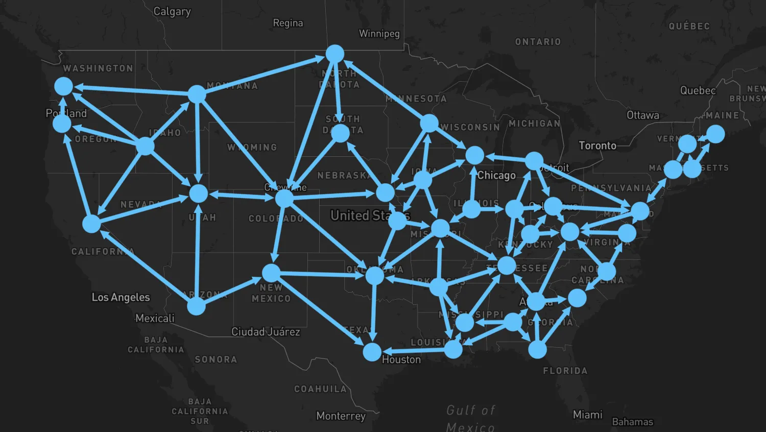
Zoom in and out on the map and see how nodes are combined and uncombined.
Combining fixed nodes that are too close to each other at a given zoom level helps reduce map clutter. It also creates combined links which summarize the links into and out of combined nodes.
This example also shows how to use event handlers to get the details of the children of combined nodes and links.
proximityCombineAPI- Proximity Combining docs
import { MapWeave } from "mapweave/mapbox";
import { NetworkLayer } from "mapweave/layers";
import { networkData, defaultView } from "./data";

const infoboxContent = document.getElementById("infobox-content");

function handleClick({ id, item }) {
  let description = "";

  if (item) {
    const { type, children } = item;
    if (type === "node" || type === "link") {
      description =
        children === undefined
          ? `Single ${type} with id ${id}`
          : `Combo ${type} with children: ${children.join(", ")}`;
    }
  }
  infoboxContent.textContent = description;
}

const mapweave = new MapWeave({
  container: "mw",
  options: { accessToken: VITE_MAPBOX_API_KEY },
});
const networkLayer = new NetworkLayer({
  data: networkData,
  options: { proximityCombine: { enabled: true, radius: 24 } },
});
mapweave.addLayer(networkLayer);
mapweave.on("click", handleClick);
mapweave.view(defaultView);const stateCapitals = [
["AL", 32.361538, -86.279118],
["AZ", 33.448457, -112.073844],
["AR", 34.736009, -92.331122],
["CA", 38.555605, -121.468926],
["CO", 39.7391667, -104.984167],
["CT", 41.767, -72.677],
["DE", 39.161921, -75.526755],
["FL", 30.4518, -84.27277],
["GA", 33.76, -84.39],
["ID", 43.613739, -116.237651],
["IL", 39.78325, -89.650373],
["IN", 39.790942, -86.147685],
["IA", 41.590939, -93.620866],
["KS", 39.04, -95.69],
["KY", 38.197274, -84.86311],
["LA", 30.45809, -91.140229],
["ME", 44.323535, -69.765261],
["MD", 38.972945, -76.501157],
["MA", 42.2352, -71.0275],
["MI", 42.7335, -84.5467],
["MN", 44.95, -93.094],
["MS", 32.32, -90.207],
["MO", 38.572954, -92.189283],
["MT", 46.595805, -112.027031],
["NE", 40.809868, -96.675345],
["NV", 39.160949, -119.753877],
["NH", 43.220093, -71.549127],
["NJ", 40.221741, -74.756138],
["NM", 35.667231, -105.964575],
["NY", 42.659829, -73.781339],
["NC", 35.771, -78.638],
["ND", 48.813343, -100.779004],
["OH", 39.962245, -83.000647],
["OK", 35.482309, -97.534994],
["OR", 44.931109, -123.029159],
["PA", 40.269789, -76.875613],
["RI", 41.82355, -71.422132],
["SC", 34, -81.035],
["SD", 44.367966, -100.336378],
["TN", 36.165, -86.784],
["TX", 30.266667, -97.75],
["UT", 40.7547, -111.892622],
["VT", 44.26639, -72.57194],
["VA", 37.54, -77.46],
["WA", 47.042418, -122.893077],
["WV", 38.349497, -81.633294],
["WI", 43.074722, -89.384444],
["WY", 41.145548, -104.802042],
];
const links = [
"AL-FL",
"AL-GA",
"AL-LA",
"AL-MS",
"AR-LA",
"AR-MO",
"AR-MS",
"AR-OK",
"AR-TN",
"AZ-NM",
"AZ-NV",
"AZ-UT",
"CA-NV",
"CA-OR",
"CO-NE",
"CO-NM",
"CO-OK",
"CO-UT",
"CO-WY",
"CT-MA",
"CT-NJ",
"CT-NY",
"CT-RI",
"DE-MD",
"DE-NJ",
"DE-PA",
"DE-VA",
"FL-GA",
"FL-SC",
"GA-SC",
"GA-TN",
"GA-WV",
"IA-KS",
"IA-MN",
"IA-MO",
"IA-NE",
"IA-WI",
"ID-MT",
"ID-NV",
"ID-OR",
"ID-UT",
"ID-WA",
"IL-IN",
"IL-MO",
"IL-WI",
"IN-KY",
"IN-MI",
"IN-OH",
"IN-TN",
"KS-MO",
"KS-NE",
"KS-OK",
"KY-OH",
"KY-TN",
"KY-WV",
"LA-MS",
"LA-TX",
"MA-ME",
"MA-NH",
"MA-RI",
"MD-PA",
"MD-VA",
"ME-NH",
"ME-VT",
"MI-OH",
"MI-PA",
"MI-WI",
"MN-ND",
"MN-NE",
"MN-WI",
"MO-OK",
"MO-TN",
"MS-TN",
"MT-ND",
"MT-UT",
"MT-WA",
"MT-WY",
"NC-SC",
"NC-VA",
"NC-WV",
"ND-SD",
"ND-WY",
"NE-SD",
"NH-NY",
"NH-VT",
"NJ-NY",
"NJ-PA",
"NM-OK",
"NM-TX",
"NV-OR",
"NV-UT",
"NY-PA",
"NY-VT",
"OH-PA",
"OH-WV",
"OK-TX",
"OR-WA",
"PA-WV",
"SD-WY",
"UT-WY",
"VA-WV",
];
const color = "#62C1F9";
const size = 8;
const width = 4;
export const networkData = Object.fromEntries([
...stateCapitals.map(([id, latitude, longitude]) => [
id,
{ type: "node", latitude, longitude, color, size },
]),
...links.map((id) => {
const [id1, id2] = id.split("-");
return [
id,
{ type: "link", id, id1, id2, end2: { arrow: true }, color, width },
];
}),
]);
export const defaultView = {
latitude: 39,
longitude: -97,
zoom: 2,
};<!doctype html>
<html>
<head>
<link rel="stylesheet" href="@ci/theme/mw/css/examples.css" />
</head>
<body>
<div id="mw">
<div class="example__infobox" style="position: absolute; margin: 5px">
<pre>Click a node or link to see its details</pre>
<pre id="infobox-content"></pre>
</div>
</div>
<script type="module" src="./code.js"></script>
</body>
</html>import React, { useRef, useState } from "react";
import { createRoot } from "react-dom/client";
import { MapWeave } from "mapweave/react/mapbox";
import { NetworkLayer } from "mapweave/react/layers";
import { networkData, defaultView } from "./data";
const mapWeaveOptions = { accessToken: VITE_MAPBOX_API_KEY };
const infoboxStyle = { position: "absolute", margin: 5 };
const networkLayerOptions = {
proximityCombine: {
enabled: true,
radius: 24,
},
};
function getDescription({ id, item }) {
let result = "";
if (item) {
const { type, children } = item;
if (type === "node" || type === "link") {
result =
children === undefined
? `Single ${type} with id ${id}`
: `Combo ${type} with children: ${children.join(", ")}`;
}
}
return result;
}
function Demo() {
const [description, setDescription] = useState("");
return (
<>
<div className="example__infobox" style={infoboxStyle}>
<pre>Click a node or link to see its details</pre>
<pre>{description}</pre>
</div>
<MapWeave
options={mapWeaveOptions}
view={defaultView}
onClick={(e) => {
setDescription(getDescription(e));
}}
>
<NetworkLayer data={networkData} options={networkLayerOptions} />
</MapWeave>
</>
);
}
const root = createRoot(document.getElementById("mw"));
root.render(<Demo />);const stateCapitals = [
["AL", 32.361538, -86.279118],
["AZ", 33.448457, -112.073844],
["AR", 34.736009, -92.331122],
["CA", 38.555605, -121.468926],
["CO", 39.7391667, -104.984167],
["CT", 41.767, -72.677],
["DE", 39.161921, -75.526755],
["FL", 30.4518, -84.27277],
["GA", 33.76, -84.39],
["ID", 43.613739, -116.237651],
["IL", 39.78325, -89.650373],
["IN", 39.790942, -86.147685],
["IA", 41.590939, -93.620866],
["KS", 39.04, -95.69],
["KY", 38.197274, -84.86311],
["LA", 30.45809, -91.140229],
["ME", 44.323535, -69.765261],
["MD", 38.972945, -76.501157],
["MA", 42.2352, -71.0275],
["MI", 42.7335, -84.5467],
["MN", 44.95, -93.094],
["MS", 32.32, -90.207],
["MO", 38.572954, -92.189283],
["MT", 46.595805, -112.027031],
["NE", 40.809868, -96.675345],
["NV", 39.160949, -119.753877],
["NH", 43.220093, -71.549127],
["NJ", 40.221741, -74.756138],
["NM", 35.667231, -105.964575],
["NY", 42.659829, -73.781339],
["NC", 35.771, -78.638],
["ND", 48.813343, -100.779004],
["OH", 39.962245, -83.000647],
["OK", 35.482309, -97.534994],
["OR", 44.931109, -123.029159],
["PA", 40.269789, -76.875613],
["RI", 41.82355, -71.422132],
["SC", 34, -81.035],
["SD", 44.367966, -100.336378],
["TN", 36.165, -86.784],
["TX", 30.266667, -97.75],
["UT", 40.7547, -111.892622],
["VT", 44.26639, -72.57194],
["VA", 37.54, -77.46],
["WA", 47.042418, -122.893077],
["WV", 38.349497, -81.633294],
["WI", 43.074722, -89.384444],
["WY", 41.145548, -104.802042],
];
const links = [
"AL-FL",
"AL-GA",
"AL-LA",
"AL-MS",
"AR-LA",
"AR-MO",
"AR-MS",
"AR-OK",
"AR-TN",
"AZ-NM",
"AZ-NV",
"AZ-UT",
"CA-NV",
"CA-OR",
"CO-NE",
"CO-NM",
"CO-OK",
"CO-UT",
"CO-WY",
"CT-MA",
"CT-NJ",
"CT-NY",
"CT-RI",
"DE-MD",
"DE-NJ",
"DE-PA",
"DE-VA",
"FL-GA",
"FL-SC",
"GA-SC",
"GA-TN",
"GA-WV",
"IA-KS",
"IA-MN",
"IA-MO",
"IA-NE",
"IA-WI",
"ID-MT",
"ID-NV",
"ID-OR",
"ID-UT",
"ID-WA",
"IL-IN",
"IL-MO",
"IL-WI",
"IN-KY",
"IN-MI",
"IN-OH",
"IN-TN",
"KS-MO",
"KS-NE",
"KS-OK",
"KY-OH",
"KY-TN",
"KY-WV",
"LA-MS",
"LA-TX",
"MA-ME",
"MA-NH",
"MA-RI",
"MD-PA",
"MD-VA",
"ME-NH",
"ME-VT",
"MI-OH",
"MI-PA",
"MI-WI",
"MN-ND",
"MN-NE",
"MN-WI",
"MO-OK",
"MO-TN",
"MS-TN",
"MT-ND",
"MT-UT",
"MT-WA",
"MT-WY",
"NC-SC",
"NC-VA",
"NC-WV",
"ND-SD",
"ND-WY",
"NE-SD",
"NH-NY",
"NH-VT",
"NJ-NY",
"NJ-PA",
"NM-OK",
"NM-TX",
"NV-OR",
"NV-UT",
"NY-PA",
"NY-VT",
"OH-PA",
"OH-WV",
"OK-TX",
"OR-WA",
"PA-WV",
"SD-WY",
"UT-WY",
"VA-WV",
];
const color = "#62C1F9";
const size = 8;
const width = 4;
export const networkData = Object.fromEntries([
...stateCapitals.map(([id, latitude, longitude]) => [
id,
{ type: "node", latitude, longitude, color, size },
]),
...links.map((id) => {
const [id1, id2] = id.split("-");
return [
id,
{ type: "link", id, id1, id2, end2: { arrow: true }, color, width },
];
}),
]);
export const defaultView = {
latitude: 39,
longitude: -97,
zoom: 2,
};<!doctype html>
<html>
<head>
<link rel="stylesheet" href="@ci/theme/mw/css/examples.css" />
</head>
<body>
<div id="mw"></div>
<script type="module" src="./code.jsx"></script>
</body>
</html>