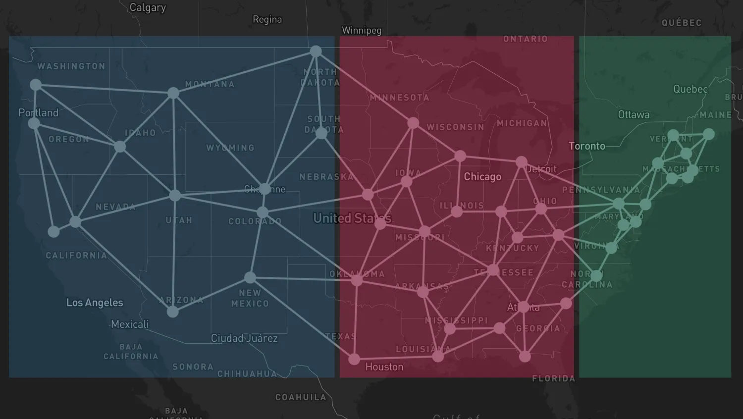
Click a region to filter out any nodes and links outside of the clicked region.
You can add event handlers to the GeoJSON layer and create a filtering interaction such as the one in this example.
Use the click event with overrideStyle() to update the styling.
Clear the styling override by calling the returned StyleReset function.
Use the onClick event prop with overrideStyles to update the styling.
- Event Handling docs
- Override Item Styles docs
import { MapWeave } from "mapweave/mapbox";
import { NetworkLayer, GeoJsonLayer } from "mapweave/layers";
import {
  nodesPerRegion,
  getRegionColor,
  networkData,
  geojsonData,
} from "./data";

const networkLayerOptions = {
  nodes: { zoomScaling: { max: 0 } },
};

const hoveredAlpha = 0.4;
const selectedAlpha = 0.5;

let selectedRegionId = null;

function filterNetworkData() {
  if (selectedRegionId === null) {
    return networkData;
  }
  const nodesToInclude = nodesPerRegion.get(selectedRegionId);
  return Object.fromEntries(
    Object.entries(networkData).filter(([id, item]) =>
      item.type === "link"
        ? nodesToInclude.has(item.id1) && nodesToInclude.has(item.id2)
        : nodesToInclude.has(id),
    ),
  );
}

// Return id if it is a valid region id, otherwise null
function getRegionId(id) {
  return nodesPerRegion.has(id) ? id : null;
}

const mapweave = new MapWeave({
  container: "mw",
  options: { accessToken: VITE_MAPBOX_API_KEY },
});
const networkLayer = new NetworkLayer({
  data: networkData,
  options: networkLayerOptions,
});
const geoJsonLayer = new GeoJsonLayer({ data: geojsonData });

mapweave.layers([networkLayer, geoJsonLayer]);

let selectStyleReset;

mapweave.on("click", ({ id }) => {
  selectStyleReset?.();
  selectedRegionId = getRegionId(id);
  networkLayer.data(filterNetworkData());
  if (selectedRegionId !== null) {
    const color = getRegionColor(selectedRegionId, selectedAlpha);
    selectStyleReset = geoJsonLayer.overrideStyle(selectedRegionId, { color });
  }
});

let hoverStyleReset;

mapweave.on("hover", ({ id }) => {
  hoverStyleReset?.();
  const regionId = getRegionId(id);
  if (regionId !== null && regionId !== selectedRegionId) {
    const color = getRegionColor(regionId, hoveredAlpha);
    hoverStyleReset = geoJsonLayer.overrideStyle(regionId, { color });
  }
});

mapweave.fitBounds();const states = [
// id, latitude, longitude, connected states
["AL", 32.361538, -86.279118, "FL", "GA", "LA", "MS"],
["AR", 34.736009, -92.331122, "LA", "MO", "MS", "OK", "TN"],
["AZ", 33.448457, -112.073844, "NM", "NV", "UT"],
["CA", 38.555605, -121.468926, "NV", "OR"],
["CO", 39.7391667, -104.984167, "NE", "NM", "OK", "UT", "WY"],
["CT", 41.767, -72.677, "MA", "NJ", "NY", "RI"],
["DE", 39.161921, -75.526755, "MD", "NJ", "PA", "VA"],
["FL", 30.4518, -84.27277, "GA", "SC"],
["GA", 33.76, -84.39, "SC", "TN", "WV"],
["IA", 41.590939, -93.620866, "KS", "MN", "MO", "NE", "WI"],
["ID", 43.613739, -116.237651, "MT", "NV", "OR", "UT", "WA"],
["IL", 39.78325, -89.650373, "IN", "MO", "WI"],
["IN", 39.790942, -86.147685, "KY", "MI", "OH", "TN"],
["KS", 39.04, -95.69, "MO", "NE", "OK"],
["KY", 38.197274, -84.86311, "OH", "TN", "WV"],
["LA", 30.45809, -91.140229, "MS", "TX"],
["MA", 42.2352, -71.0275, "ME", "NH", "RI"],
["MD", 38.972945, -76.501157, "PA", "VA"],
["ME", 44.323535, -69.765261, "NH", "VT"],
["MI", 42.7335, -84.5467, "OH", "PA", "WI"],
["MN", 44.95, -93.094, "ND", "NE", "WI"],
["MO", 38.572954, -92.189283, "OK", "TN"],
["MS", 32.32, -90.207, "TN"],
["MT", 46.595805, -112.027031, "ND", "UT", "WA", "WY"],
["NC", 35.771, -78.638, "SC", "VA", "WV"],
["ND", 48.813343, -100.779004, "SD", "WY"],
["NE", 40.809868, -96.675345, "SD"],
["NH", 43.220093, -71.549127, "NY", "VT"],
["NJ", 40.221741, -74.756138, "NY", "PA"],
["NM", 35.667231, -105.964575, "OK", "TX"],
["NV", 39.160949, -119.753877, "OR", "UT"],
["NY", 42.659829, -73.781339, "PA", "VT"],
["OH", 39.962245, -83.000647, "PA", "WV"],
["OK", 35.482309, -97.534994, "TX"],
["OR", 44.931109, -123.029159, "WA"],
["PA", 40.269789, -76.875613, "WV"],
["RI", 41.82355, -71.422132],
["SC", 34, -81.035],
["SD", 44.367966, -100.336378, "WY"],
["TN", 36.165, -86.784],
["TX", 30.266667, -97.75],
["UT", 40.7547, -111.892622, "WY"],
["VA", 37.54, -77.46, "WV"],
["VT", 44.26639, -72.57194],
["WA", 47.042418, -122.893077],
["WI", 43.074722, -89.384444],
["WV", 38.349497, -81.633294],
["WY", 41.145548, -104.802042],
];
function makeNetworkData() {
const result = {};
for (const [id1, latitude, longitude, ...links] of states) {
result[id1] = {
type: "node",
latitude,
longitude,
};
for (const id2 of links) {
const id = `${id1}-${id2}`;
result[id] = {
type: "link",
id1,
id2,
};
}
}
return result;
}
export const networkData = makeNetworkData();
const standardAlpha = 0.3;
const regions = {
blueRegion: {
south: 29,
west: -125,
north: 49.6,
east: -99.3,
rgb: "36, 113, 163",
},
redRegion: {
south: 29,
west: -98.9,
north: 49.6,
east: -80.4,
rgb: "255, 23, 100",
},
greenRegion: {
south: 29,
west: -80,
north: 49.6,
east: -68,
rgb: "15, 171, 124",
},
};
function isPointInRegion(latitude, longitude, { south, west, north, east }) {
return (
longitude >= west &&
longitude <= east &&
latitude >= south &&
latitude <= north
);
}
// Determine which nodes are in which regions
export const nodesPerRegion = new Map();
for (const [regionId, region] of Object.entries(regions)) {
const nodesInThisRegion = new Set();
for (const [nodeId, latitude, longitude] of states) {
if (isPointInRegion(latitude, longitude, region)) {
nodesInThisRegion.add(nodeId);
}
}
nodesPerRegion.set(regionId, nodesInThisRegion);
}
export function getRegionColor(id, alpha) {
return `rgba(${regions[id].rgb}, ${alpha})`;
}
function makeGeoJsonData() {
return {
type: "FeatureCollection",
features: Object.entries(regions).map(
([id, { south, west, north, east }]) => {
return {
type: "Feature",
id,
properties: {
color: getRegionColor(id, standardAlpha),
},
geometry: {
type: "Polygon",
coordinates: [
[
[west, south],
[west, north],
[east, north],
[east, south],
[west, south],
],
],
},
};
},
),
};
}
export const geojsonData = makeGeoJsonData();<!doctype html>
<html>
<head>
<link rel="stylesheet" href="@ci/theme/mw/css/examples.css" />
</head>
<body>
<div id="mw"></div>
<script type="module" src="./code.js"></script>
</body>
</html>import React, { useState } from "react";
import { createRoot } from "react-dom/client";
import { MapWeave } from "mapweave/react/mapbox";
import { NetworkLayer, GeoJsonLayer } from "mapweave/react/layers";
import {
nodesPerRegion,
getRegionColor,
networkData,
geojsonData,
} from "./data";
const mapWeaveOptions = { accessToken: VITE_MAPBOX_API_KEY };
const networkLayerOptions = {
nodes: { zoomScaling: { max: 0 } },
};
const hoveredAlpha = 0.4;
const selectedAlpha = 0.5;
function filterNetworkData(selectedRegionId) {
if (selectedRegionId === null) {
return networkData;
}
const nodesToInclude = nodesPerRegion.get(selectedRegionId);
return Object.fromEntries(
Object.entries(networkData).filter(([id, item]) =>
item.type === "link"
? nodesToInclude.has(item.id1) && nodesToInclude.has(item.id2)
: nodesToInclude.has(id),
),
);
}
// Return id if it is a valid region id, otherwise null
function getRegionId(id) {
return nodesPerRegion.has(id) ? id : null;
}
function Demo() {
const [selectedRegionId, setSelectedRegionId] = useState(null);
const [hoveredRegionId, setHoveredRegionId] = useState(null);
const overrideStyles = [];
if (hoveredRegionId) {
overrideStyles.push({
ids: hoveredRegionId,
overrideStyle: { color: getRegionColor(hoveredRegionId, hoveredAlpha) },
});
}
if (selectedRegionId) {
overrideStyles.push({
ids: selectedRegionId,
overrideStyle: { color: getRegionColor(selectedRegionId, selectedAlpha) },
});
}
return (
<MapWeave
options={mapWeaveOptions}
onClick={({ id }) => {
setSelectedRegionId(getRegionId(id));
}}
onHover={({ id }) => {
setHoveredRegionId(getRegionId(id));
}}
>
<NetworkLayer
data={filterNetworkData(selectedRegionId)}
options={networkLayerOptions}
/>
<GeoJsonLayer data={geojsonData} overrideStyles={overrideStyles} />
</MapWeave>
);
}
const root = createRoot(document.getElementById("mw"));
root.render(<Demo />);const states = [
// id, latitude, longitude, connected states
["AL", 32.361538, -86.279118, "FL", "GA", "LA", "MS"],
["AR", 34.736009, -92.331122, "LA", "MO", "MS", "OK", "TN"],
["AZ", 33.448457, -112.073844, "NM", "NV", "UT"],
["CA", 38.555605, -121.468926, "NV", "OR"],
["CO", 39.7391667, -104.984167, "NE", "NM", "OK", "UT", "WY"],
["CT", 41.767, -72.677, "MA", "NJ", "NY", "RI"],
["DE", 39.161921, -75.526755, "MD", "NJ", "PA", "VA"],
["FL", 30.4518, -84.27277, "GA", "SC"],
["GA", 33.76, -84.39, "SC", "TN", "WV"],
["IA", 41.590939, -93.620866, "KS", "MN", "MO", "NE", "WI"],
["ID", 43.613739, -116.237651, "MT", "NV", "OR", "UT", "WA"],
["IL", 39.78325, -89.650373, "IN", "MO", "WI"],
["IN", 39.790942, -86.147685, "KY", "MI", "OH", "TN"],
["KS", 39.04, -95.69, "MO", "NE", "OK"],
["KY", 38.197274, -84.86311, "OH", "TN", "WV"],
["LA", 30.45809, -91.140229, "MS", "TX"],
["MA", 42.2352, -71.0275, "ME", "NH", "RI"],
["MD", 38.972945, -76.501157, "PA", "VA"],
["ME", 44.323535, -69.765261, "NH", "VT"],
["MI", 42.7335, -84.5467, "OH", "PA", "WI"],
["MN", 44.95, -93.094, "ND", "NE", "WI"],
["MO", 38.572954, -92.189283, "OK", "TN"],
["MS", 32.32, -90.207, "TN"],
["MT", 46.595805, -112.027031, "ND", "UT", "WA", "WY"],
["NC", 35.771, -78.638, "SC", "VA", "WV"],
["ND", 48.813343, -100.779004, "SD", "WY"],
["NE", 40.809868, -96.675345, "SD"],
["NH", 43.220093, -71.549127, "NY", "VT"],
["NJ", 40.221741, -74.756138, "NY", "PA"],
["NM", 35.667231, -105.964575, "OK", "TX"],
["NV", 39.160949, -119.753877, "OR", "UT"],
["NY", 42.659829, -73.781339, "PA", "VT"],
["OH", 39.962245, -83.000647, "PA", "WV"],
["OK", 35.482309, -97.534994, "TX"],
["OR", 44.931109, -123.029159, "WA"],
["PA", 40.269789, -76.875613, "WV"],
["RI", 41.82355, -71.422132],
["SC", 34, -81.035],
["SD", 44.367966, -100.336378, "WY"],
["TN", 36.165, -86.784],
["TX", 30.266667, -97.75],
["UT", 40.7547, -111.892622, "WY"],
["VA", 37.54, -77.46, "WV"],
["VT", 44.26639, -72.57194],
["WA", 47.042418, -122.893077],
["WI", 43.074722, -89.384444],
["WV", 38.349497, -81.633294],
["WY", 41.145548, -104.802042],
];
function makeNetworkData() {
const result = {};
for (const [id1, latitude, longitude, ...links] of states) {
result[id1] = {
type: "node",
latitude,
longitude,
};
for (const id2 of links) {
const id = `${id1}-${id2}`;
result[id] = {
type: "link",
id1,
id2,
};
}
}
return result;
}
export const networkData = makeNetworkData();
const standardAlpha = 0.3;
const regions = {
blueRegion: {
south: 29,
west: -125,
north: 49.6,
east: -99.3,
rgb: "36, 113, 163",
},
redRegion: {
south: 29,
west: -98.9,
north: 49.6,
east: -80.4,
rgb: "255, 23, 100",
},
greenRegion: {
south: 29,
west: -80,
north: 49.6,
east: -68,
rgb: "15, 171, 124",
},
};
function isPointInRegion(latitude, longitude, { south, west, north, east }) {
return (
longitude >= west &&
longitude <= east &&
latitude >= south &&
latitude <= north
);
}
// Determine which nodes are in which regions
export const nodesPerRegion = new Map();
for (const [regionId, region] of Object.entries(regions)) {
const nodesInThisRegion = new Set();
for (const [nodeId, latitude, longitude] of states) {
if (isPointInRegion(latitude, longitude, region)) {
nodesInThisRegion.add(nodeId);
}
}
nodesPerRegion.set(regionId, nodesInThisRegion);
}
export function getRegionColor(id, alpha) {
return `rgba(${regions[id].rgb}, ${alpha})`;
}
function makeGeoJsonData() {
return {
type: "FeatureCollection",
features: Object.entries(regions).map(
([id, { south, west, north, east }]) => {
return {
type: "Feature",
id,
properties: {
color: getRegionColor(id, standardAlpha),
},
geometry: {
type: "Polygon",
coordinates: [
[
[west, south],
[west, north],
[east, north],
[east, south],
[west, south],
],
],
},
};
},
),
};
}
export const geojsonData = makeGeoJsonData();<!doctype html>
<html>
<head>
<link rel="stylesheet" href="@ci/theme/mw/css/examples.css" />
</head>
<body>
<div id="mw"></div>
<script type="module" src="./code.jsx"></script>
</body>
</html>